
A primary school in Minab was attacked by a bombing on February 28 2026 which resulted in multiple deaths that included numerous young girls who were between seven and twelve years old. The assault on Shajareh Tayyebeh Primary School has become one of the deadliest incidents linked to the ongoing Iran–Israel–US conflict.
The tragedy has sparked a heated debate over who was responsible. Donald Trump publicly claimed that Iran carried out the strike, describing it as the result of inaccurate Iranian weaponry. However, the investigators and open-source analysts together with satellite imagery evidence present findings that lead to an alternative conclusion.
The following section identifies evidence which investigators currently examine.
Location of the School
The targeted school was located next to facilities belonging to the Islamic Revolutionary Guard Corps (IRGC), specifically a naval barracks and support buildings.
Investigators used satellite imagery to verify the actual site location through comparing it with video evidence from the scene. The historical satellite images demonstrate that the school building functioned as part of the IRGC complex yet it remained distinct from the complex because walls had divided it for nearly ten years.
The building had various displays which showed its function as an educational institution through its vibrant murals and small sports grounds which satellite imaging could detect. The available information does not show any evidence that the building served military functions when the strike occurred.
The IRGC base located nearby explains why strikes occurred throughout the area.
Videos From the Aftermath
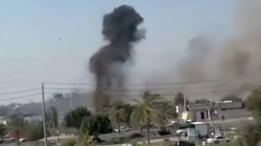
Several videos shared on Iranian social media in the hours following the explosion were verified by journalists and investigators. The clips display the same destroyed school from different viewing positions.
One of the videos reveals thick smoke rising from behind a fence near the school, in the direction of the IRGC naval compound. The footage showed that the school got hit when multiple strikes targeted the military base which operated next to it.
Satellite Images of the Strike
Satellite imagery released on March 4 confirmed widespread destruction in the area. The images show:
- The complete destruction of the school building
- Four additional buildings destroyed nearby
- All damaged structures located within or near the IRGC compound
This pattern supports the theory that the school was struck during a broader attack targeting nearby military infrastructure.
Missile Footage Analysis
A video released by Iranian state media was later analyzed by Bellingcat, which used geolocation techniques to identify the strike location.
By comparing visible landmarks—such as buildings, roads, and water towers—with satellite images, analysts determined the missile struck the IRGC compound next to the school.
Weapons experts identified the projectile as a Tomahawk cruise missile. According to munitions specialists, this weapon is operated by the United States Armed Forces and is not known to be part of Israel’s arsenal.
Experts also ruled out the possibility that the missile was Iran’s Soumar missile, noting clear design differences.
US Military Operations in the Area
While the US has not acknowledged striking the school, it confirmed conducting attacks in southern Iran as part of Operation Epic Fury.
During a Pentagon briefing on March 4, US officials presented a map highlighting locations of strikes carried out by American and Israeli forces. One marked strike location corresponds closely with Minab’s position along Iran’s southern coastline.
According to military briefings, US forces focused attacks along southern coastal areas, while Israeli operations were concentrated in western Iran.
Claims of an Iranian Missile Misfire Questioned
Shortly after the attack, several social media posts claimed the explosion was caused by an Iranian missile that malfunctioned. These claims were supported by images that supposedly showed the failed weapon.
However, investigators later determined the photos were taken nearly 1,600 km away in the northern city of Zanjan.
The evidence included:
- Snow-covered mountains in the background, which do not exist near Minab’s warm coastal region
- A visible dental clinic sign that was traced to a building in Zanjan
These findings undermined the theory that an Iranian misfire caused the tragedy.
International Reaction
The bombing has drawn strong condemnation from global organizations, including UNESCO, which described the attack on a school as a serious violation of international law.
As investigations continue, analysts say more verified evidence will be needed before final responsibility for the strike can be officially determined.


Women’s Reservation Bill Fails in Lok Sabha; Rahul Gandhi Slams Centre, Credits Opposition Unity